 CHARRON 2025 Challenge
BERICHT VAN DE JURY
03-10-2024 -- Seizoen 2025 is geopend. Registratie is opnieuw vereist, zoals gewoonlijk.
Uitgebreide gegevens CHARRON.line proef06-08-2025 -- Martijn EERDEKENS -- 1844,1 punten
Scoring versie: 24.03
LOGGER GEGEVENS
Vlucht datum: 06/08/2025
Piloot: EERDEKENS MARTIJN
Zweefvliegtuig: D-6651
Toestel type: LS 3 Klasse: CLUB
Logger type: Naviter d.o.o. s/n: 4sc
Logger file: 2025-08-06-NAV-4SC-01.IGC
Motor detectie: ENL
ENL Threshold: 300
SAMENVATTING
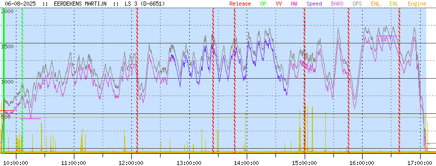
Vluchttijd : 07:22:05
Duurvlucht : 07:19:04
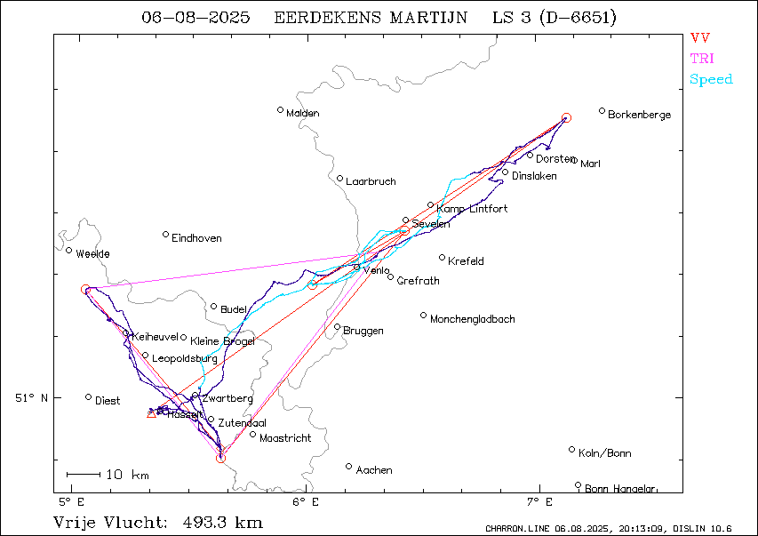
Vrije vlucht : 493.3 km
Fasttrack : 84.3 kmh
Opgegeven proef: 150.7 km
Driehoek : 231.9 km
Hoogtewinst : 1171.0 m
VLUCHTGEGEVENS ALGEMEEN
Vliegveld van vertrek
EBZH Hasselt BeNeLux: JA
Vertrekpunt
pos.: 50°58.253'N 5°22.810'E
tijd: 09:44:11 UTC
alti: -68 m
Ontkoppelpunt
pos.: 50°57.849'N 5°20.081'E = 257° 3.3 km van vertrek
tijd: 09:47:12 UTC
alti: 543 m
Landingspunt
pos.: 50°58.250'N 5°22.650'E = 268° 0.2 km van vertrek
tijd: 17:06:16 UTC
alti: -37 m
Afstand take-off tot landing: 0.2
Totale vluchtduur: 07:22:05
Motorgebruik
aantal keren: 0
VRIJE VLUCHT ANALYSE
Keerpunten vrije vlucht optimalisatie: 7
Start : 50°57.849'N 5°20.081'E @ 09:47:12 UTC, 543 m
punt 1: 51°45.718'N 7°07.864'E @ 12:06:00 UTC, 978 m
punt 2: 51°18.761'N 6°01.448'E @ 13:24:54 UTC, 1426 m
punt 3: 51°27.602'N 6°25.612'E @ 13:47:08 UTC, 1359 m
punt 4: 50°50.666'N 5°38.136'E @ 14:59:37 UTC, 1180 m
punt 5: 51°17.741'N 5°02.783'E @ 15:45:40 UTC, 997 m
Finish: 50°52.258'N 5°38.085'E @ 16:38:32 UTC, 1273 m
Benen vrije vlucht optimalisatie
been 1: 153.4 km 54° @ 66.3 km/h
been 2: 91.6 km 237° @ 69.7 km/h
been 3: 32.5 km 59° @ 87.6 km/h
been 4: 88.1 km 219° @ 72.9 km/h
been 5: 65.0 km 321° @ 84.7 km/h
been 6: 62.7 km 139° @ 71.2 km/h
Afgelegde afstand: 493.3 km
Duur: 06:51:20
Gemiddelde snelheid: 72.0 km/h
Afst. start - vliegveld van vertrek: 3.3 km
Afst finish - vliegveld van vertrek: 21.1 km
Starthoogte: 543.0 m
Finishhoogte: 1273.0 m
Hoogteverlies vrije vlucht: -730 m
Totale score afstand: 493.3 km
BESTE SNELHEIDSTRAJECT ANALYSE
Duur van snelheidscompetitie: 2 uur
Startpunt
pos.: 51°36.644'N 6°42.528'E = 52° 116.9 km van vertrek
tijd: 12:41:22 UTC
alti: 1327 m
Finishpunt
pos.: 51°01.994'N 5°32.357'E = 58° 13.1 km van vertrek
tijd: 14:41:22 UTC
alti: 794 m
Grootste afstand in 2 uur: 168.5 km
Beste snelheid in 2 uur: 84.3 km/h
Hoogteverlies: 533 m
OPGEGEVEN PROEF ANALYSE
Minimaal toegelaten lengte van de benen: 10 km
Opgegeven proef: 550.1 km GELDIG
vertrek: 0°00.000'N 0°00.000'E
start: HASSELT KIEWIT 50°58.200'N 5°22.500'E
punt 1: SENDEN 51°54.070'N 7°29.520'E 180.0 km 54°
punt 2: NIJMEGEN BRUG 51°51.060'N 5°52.340'E 111.7 km 268°
punt 3: BORKENBERGE 51°46.750'N 7°17.120'E 97.8 km 94°
finish: HASSELT KIEWIT 50°58.200'N 5°22.500'E 160.6 km 237°
landing: 0°00.000'N 0°00.000'E
Keerpunten gerond en afgelegde afstand
start: HASSELT KIEWIT @ 10:06:14 UTC, 728 m
punt 1: SENDEN niet gerond
afbreekpunt: 51°45.718'N 7°07.864'E @ 12:06:00 UTC, 978 m : 150.7 km 75.5 km/h
Proef NIET GELUKT
Afgelegde afstand: 150.7 km
Duur van de proef: 01:59:46
Gemiddelde snelheid: 75.5 km/h
Start hoogte: 452 m
Hoogte passeren start: 728 m
Hoogte aan break-punt: 978 m
Hoogteverlies over proef: -526 m
Totale score afstand: 150.7 km
DRIEHOEK ANALYSE
Been 0: 78.1 km
Been 1: 64.9 km
Been 2: 88.9 km
Totaal: 231.9 km
DUURVLUCHT ANALYSE
Blok langste zweefvlucht
begin: 09:47:12 UTC
einde: 17:06:16 UTC
duur: 07:19:04
HOOGTEWINST ANALYSE
Blok grootste hoogtewinst
laag punt: 428 m @ 10:15:03 UTC
hoog punt: 1599 m @ 16:24:54 UTC
hoogtewinst: 1171 m
CHARRONDE ANALYSE
Eerste punt: 14:59:37 bearing 94.0°
Tweede punt: 15:45:40 bearing 41.6°
Totale hoek: -52.4°
MELDINGEN EVALUATIEPROGRAMMA
Rekentijd 4947
| |||||||||||||||||||||||||||||||||||||||||||||||||||||||||

