[Inloggen]
 CHARRON 2023 Challenge
BERICHT VAN DE JURY
22-09-2022 -- De charronline-website werd verhuisd naar een nieuwe server. En tegelijkertijd werd seizoen 2023 geopend. Registratie is opnieuw vereist, zoals gewoonlijk.
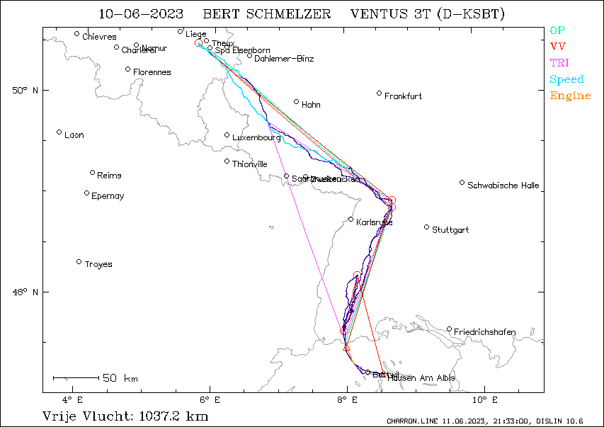
Uitgebreide gegevens CHARRON.line proef10-06-2023 -- Bert Jr. SCHMELZER -- 3400,7 punten
Scoring versie: 20.02
LOGGER GEGEVENS
Vlucht datum: 10/06/2023
Piloot: BERT SCHMELZER
Zweefvliegtuig: D-KSBT
Toestel type: VENTUS 3T Klasse: 18-METER
Logger type: LX Navigation d.o.o. s/n: agj
Logger file: 2023-06-10-LXV-AGJ-01.IGC
Motor detectie: ENL
ENL Threshold: 300
SAMENVATTING
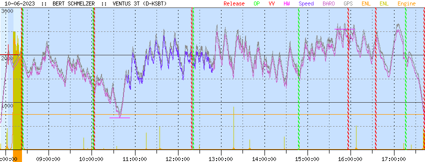
Vluchttijd : 09:50:02
Duurvlucht : 09:20:44
Vrije vlucht : 1037.2 km
Fasttrack : 138.3 kmh
Opgegeven proef: 805.7 km
Driehoek : 579.2 km
Hoogtewinst : 1876.0 m
VLUCHTGEGEVENS ALGEMEEN
Vliegveld van vertrek
LSZN Hausen Am Albis BeNeLux: NEE
Vertrekpunt
pos.: 47°14.312'N 8°31.198'E
tijd: 07:52:51 UTC
alti: 573 m
Ontkoppelpunt
pos.: 47°15.158'N 8°15.901'E = 275° 19.3 km van vertrek
tijd: 08:03:51 UTC
alti: 2006 m
Landingspunt
pos.: 47°14.314'N 8°30.914'E = 271° 0.4 km van vertrek
tijd: 17:42:53 UTC
alti: 584 m
Afstand take-off tot landing: 0.4
Totale vluchtduur: 09:50:02
Motorgebruik
aantal keren: 1
totale motortijd: 11.3 min
VRIJE VLUCHT ANALYSE
Keerpunten vrije vlucht optimalisatie: 7
Start : 47°31.197'N 7°59.790'E @ 08:22:09 UTC, 1965 m
punt 1: 48°57.784'N 8°42.107'E @ 10:03:21 UTC, 1173 m
punt 2: 50°31.686'N 5°44.109'E @ 12:18:54 UTC, 1929 m
punt 3: 48°53.659'N 8°42.241'E @ 14:47:42 UTC, 1544 m
punt 4: 47°40.350'N 7°57.347'E @ 15:56:06 UTC, 2296 m
punt 5: 48°13.694'N 8°09.930'E @ 16:34:53 UTC, 2278 m
Finish: 47°14.302'N 8°32.072'E @ 17:42:08 UTC, 754 m
Benen vrije vlucht optimalisatie
been 1: 168.8 km 18° @ 100.1 km/h
been 2: 275.7 km 310° @ 122.0 km/h
been 3: 280.8 km 129° @ 113.2 km/h
been 4: 146.8 km 202° @ 128.7 km/h
been 5: 63.7 km 14° @ 98.6 km/h
been 6: 113.5 km 166° @ 101.3 km/h
Afgelegde afstand: 1049.3 km
Duur: 09:19:59
Gemiddelde snelheid: 112.4 km/h
Afst. start - vliegveld van vertrek: 50.4 km
Afst finish - vliegveld van vertrek: 1.1 km
Starthoogte: 1965.0 m
Finishhoogte: 754.0 m
Hoogteverlies vrije vlucht: 1211 m
Totale score afstand: 1037.2 km
BESTE SNELHEIDSTRAJECT ANALYSE
Duur van snelheidscompetitie: 2 uur
Startpunt
pos.: 49°17.155'N 8°03.053'E = 352° 230.3 km van vertrek
tijd: 10:47:42 UTC
alti: 1575 m
Finishpunt
pos.: 50°11.615'N 6°24.150'E = 335° 363.6 km van vertrek
tijd: 12:47:42 UTC
alti: 1721 m
Grootste afstand in 2 uur: 276.5 km
Beste snelheid in 2 uur: 138.3 km/h
Hoogteverlies: -146 m
OPGEGEVEN PROEF ANALYSE
Minimaal toegelaten lengte van de benen: 10 km
Opgegeven proef: 805.7 km GELDIG
vertrek: 0°00.000'N 0°00.000'E
start: SISSELER FABRIK 47°32.983'N 7°58.867'E
punt 1: PFORZHEIM KATHARINENTHALER HOF 48°55.833'N 8°42.417'E 162.7 km 19°
punt 2: EX7 50°20.000'N 6°10.000'E 240.8 km 311°
punt 3: PFORZHEIM BF 48°53.617'N 8°42.200'E 243.4 km 130°
finish: SISSELER FABRIK 47°32.983'N 7°58.867'E 158.8 km 200°
landing: 0°00.000'N 0°00.000'E
Keerpunten gerond en afgelegde afstand
start: SISSELER FABRIK @ 08:23:42 UTC, 1712 m
punt 1: PFORZHEIM KATHARINENTHALER HOF @ 10:01:42 UTC, 1211 m : 162.7 km 99.6 km/h
punt 2: EX7 @ 12:20:57 UTC, 1783 m : 240.8 km 103.8 km/h
punt 3: PFORZHEIM BF @ 14:47:43 UTC, 1544 m : 243.4 km 99.5 km/h
finish: SISSELER FABRIK @ 17:16:00 UTC, 1885 m : 158.8 km 64.2 km/h
Proef GELUKT
Afgelegde afstand: 805.7 km
Duur van de proef: 08:52:18
Gemiddelde snelheid: 90.8 km/h
Start hoogte: 1712 m
Hoogte passeren start: 1712 m
Hoogte passeren finish: 1885 m
Hoogteverlies over proef: -173 m
Totale score afstand: 805.7 km
DRIEHOEK ANALYSE
Been 0: 162.2 km
Been 1: 254.9 km
Been 2: 162.2 km
Totaal: 579.2 km
DUURVLUCHT ANALYSE
Blok langste zweefvlucht
begin: 08:22:09 UTC
einde: 17:42:53 UTC
duur: 09:20:44
HOOGTEWINST ANALYSE
Blok grootste hoogtewinst
laag punt: 672 m @ 10:38:40 UTC
hoog punt: 2548 m @ 15:51:14 UTC
hoogtewinst: 1876 m
MELDINGEN EVALUATIEPROGRAMMA
Rekentijd 50100
| |||||||||||||||||||||||||||||||||||||||||||||||||||||||||

